
A journey into the borderland of infinite nature
The Via Francigena is the ancient thousand-year-old pilgrimage route that connects Canterbury to Rome, crossing Europe with enchanting scenery and locations rich in history.
One of the most fascinating sections of this journey is in Lunigiana, a historic border area between Tuscany, Liguria and Emilia Romagna. The stretch from Cisa Pass to Sarzana, stage 22 of Via Francigena in Italy, not only offers an extraordinary pilgrimage experience, but even the discovery of medieval villages and castles, events and reenactments, tasty typical products and centuries-old traditions.
The recommended route is divided into 3 stages, which can be integrated and modified depending on your level of training and any variations of the route.
Lunigiana is in fact crossed by Parma-La Spezia railway line with recurring stops in Pontremoli, Filattiera, Villafranca-Bagnone, Aulla and Sarzana, easily reachable along the itinerary.
The journey starts from Cisa Pass (reachable by taxi or ProntoBus), a historic pass between Tuscany and Emilia Romagna, already used by the Romans and Lombards as a connection between the Po Valley and the Tyrrhenian Sea. A balcony with a breathtaking view of the Tuscan-Emilian Apennines and the Magra river valley marks the beginning of the route, which continues up to Mount Cucchero which dominates the town of Gravagna and the Valdantena.
Here, a steep descent leads to the hamlets of Cavezzana d'Antena and Groppoli, until crossing the Civasola stream on the "dancing bridge". You gain altitude to meet the first village of Valdantena: Previdè, from the Latin "previdens = who sees first", an ancient lookout point.
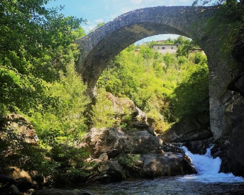
Among terraces of olive trees and vineyards, you arrive at Groppodalosio and Valle Scura bridge, symbol of the Via Francigena in Lunigiana, which here crosses the rushing waters of Magra river. On the other bank, gently climbing, you come across the rural villages of Casalina, Versola and Toplecca, until you reach the Crocetta Pass.
Here begins the descent towards the perched village of Arzengio, with its typical circular shape, and then the arrival in Pontremoli where the Piagnaro Castle, which houses the Museum of Lunigiana Stele Statues, dominates the village built on a natural peninsula between the Magra river and the Verde river, also recognized as the “Key and gateway to Tuscany”.
Where to sleep: Hostel of Piagnaro Castle and Hostel of Capuchin Fathers Convent.
The journey starts from Cisa Pass (reachable by taxi or ProntoBus), a historic pass between Tuscany and Emilia Romagna, already used by the Romans and Lombards as a connection between the Po Valley and the Tyrrhenian Sea. A balcony with a breathtaking view of the Tuscan-Emilian Apennines and the Magra river valley marks the beginning of the route, which continues up to Mount Cucchero which dominates the town of Gravagna and the Valdantena.
Here, a steep descent leads to the hamlets of Cavezzana d'Antena and Groppoli, until crossing the Civasola stream on the "dancing bridge". You gain altitude to meet the first village of Valdantena: Previdè, from the Latin "previdens = who sees first", an ancient lookout point.
Among terraces of olive trees and vineyards, you arrive at Groppodalosio and Valle Scura bridge, symbol of the Via Francigena in Lunigiana, which here crosses the rushing waters of Magra river. On the other bank, gently climbing, you come across the rural villages of Casalina, Versola and Toplecca, until you reach the Crocetta Pass.
Here begins the descent towards the perched village of Arzengio, with its typical circular shape, and then the arrival in Pontremoli where the Piagnaro Castle, which houses the Museum of Lunigiana Stele Statues, dominates the village built on a natural peninsula between the Magra river and the Verde river, also recognized as the “Key and gateway to Tuscany”.
Where to sleep: Hostel of Piagnaro Castle and Hostel of Capuchin Fathers Convent.
- straighten
Length20 km
- schedule
DurationOne day
- trending_down
Descent-1200 m
- trending_up
Ascent+400 m
This stage is particularly demanding given its length, but offers unique views of Lunigiana valley floor.
After crossing Pontremoli, in the direction of the wonderful Convent of Santissima Annunziata, you quickly cross an industrial area to enter the Municipality of Filattiera, with the characteristic villages of Scorcetoli, Canale and Ponticello. We are in the fluvial area of the Magra River, a splendid example of a rural landscape that accompanies the traveler to the Parish Church of San Stefano in Sorano, a place of ancient border at the time of the Byzantines and Lombards.
Continuing uphill, you cross the village of Filattiera, the medieval capital of Malaspina marquises of Spino Fiorito, with the castle and the Church of San Giorgio. We continue the path in the woods until we reach Filetto, a wonderful fortified village, to then cross the Bagnone stream and we arrive at the perched village of Virgoletta.
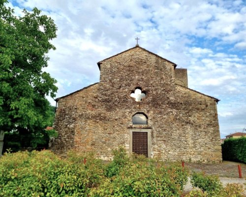
It begins a long path through the woods, leading first to the small town of Fornoli and then to Terrarossa Castle. Following the recent Green Way, you arrive in the center of Aulla, well represented by the Abbey and Museum of San Caprasio, a thousand-year-old treasure chest of ancient treasures linked to religion and pilgrimage.
Where to sleep: Hostel of San Caprasio Abbey.
This stage is particularly demanding given its length, but offers unique views of Lunigiana valley floor.
After crossing Pontremoli, in the direction of the wonderful Convent of Santissima Annunziata, you quickly cross an industrial area to enter the Municipality of Filattiera, with the characteristic villages of Scorcetoli, Canale and Ponticello. We are in the fluvial area of the Magra River, a splendid example of a rural landscape that accompanies the traveler to the Parish Church of San Stefano in Sorano, a place of ancient border at the time of the Byzantines and Lombards.
Continuing uphill, you cross the village of Filattiera, the medieval capital of Malaspina marquises of Spino Fiorito, with the castle and the Church of San Giorgio. We continue the path in the woods until we reach Filetto, a wonderful fortified village, to then cross the Bagnone stream and we arrive at the perched village of Virgoletta.
It begins a long path through the woods, leading first to the small town of Fornoli and then to Terrarossa Castle. Following the recent Green Way, you arrive in the center of Aulla, well represented by the Abbey and Museum of San Caprasio, a thousand-year-old treasure chest of ancient treasures linked to religion and pilgrimage.
Where to sleep: Hostel of San Caprasio Abbey.
- straighten
Length32.5 km
- schedule
DurationOne/two days
- trending_down
Descent-550 m
- trending_up
Ascent+400 m
In front of the mighty Brunella Fortress, we leave Aulla. After crossing the Aulella stream, you quickly gain altitude up to the perched village of Bibola where the view extends from the Tuscan-Emilian Apennines to the Apuan Alps.
The route continues along the secondary asphalt road that leads to Vecchietto village. Here you take the path that goes up to the Quattro Strade pass. After crossing this ridge, you descend to the village of Ponzano Superiore which offers a splendid panorama from the Gulf of Poets, to the Montemarcello-Magra park and the Versilia coast.
Continuing downhill on easy dirt roads, among bucolic olive groves, you come across the ruins of the Brina Castle. Going further down, you reach the Lunense Canal, a grandiose 19th century hydraulic work serving the irrigation system of the Luni plain which accompanies the pilgrim to the gates of Sarzana, between fortresses and bastions: a worthy conclusion to the splendid hiking itinerary in Lunigiana.
Where to sleep: Hostel of Carmine Parish Church.
- straighten
Length18.5 Km
- schedule
DurationOne day
- trending_down
Descent-700 m
- trending_up
Ascent+650 m